openPR Recherche & Suche
Presseinformation

Tsunami Redraws Indian Ocean Maps

24.01.200511:59 UhrWissenschaft, Forschung, Bildung
Bild: Tsunami Redraws Indian Ocean Maps
Satellite images of Banda Aceh South, Sumatra, before and after the tsunami.

(openPR) Reports continue to surface of vanished islands, restructured coastlines, and uncertain shipping lanes. Geographers are responding with satellites and survey vessels to determine which areas are hardest hit. Their findings are helping and rechart maritime routes essential for the delivery of relief supplies.


David Skole and his team are using 30-meter-resolution (33 yards) satellite imagery to determine which areas were hardest hit and are most in need of help. Skole directs the Center for Global Change and Earth Observations (CGCEO) at Michigan State University. The group works in conjunction with Landsat.org, NASA, the United States Geological Survey, and other organizations.

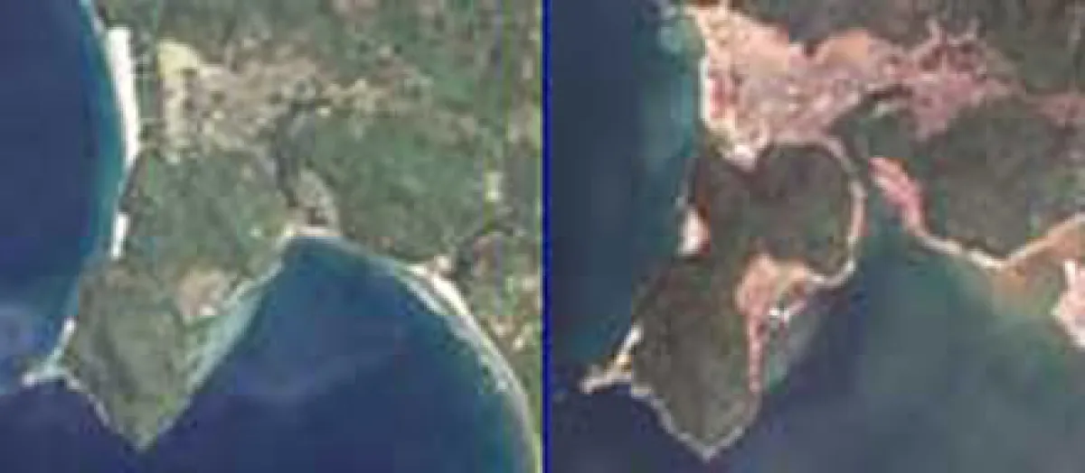
CGCEO is concentrating much of its effort on Indonesia's Aceh Province, the heavily damaged northern region on the island of Sumatra. Even in this area that bore the brunt of the wave's destruction, the geographical impacts vary with shape of the coastline and offshore environment.

"The perspective you might get from the news is that the entire province was wiped out," Skole said. "That's not true, only about 400 to 500 square kilometers [150 to 190 square miles] were damaged along a narrow ribbon of coastline. And some pockets were worse than others."

"Unfortunately when you cross-map the damage maps with population-density maps and the locations of urban areas, you see that the areas most damaged were also the areas of high population density," he continued. "People are settling in these high-risk zones along the coastline."

Interestingly, when it comes to determining where relief efforts are most needed, satellite images are sometimes proving more reliable than reports from the scene.

"Some of these areas are remote or cut off from transportation and communication," Skole explained. "If they do have communication, people may call in and say, We need help, it's a total mess here. Well, everybody is saying that, so how do you map it?"

Skole is working to create such a relief-need map with colleagues in the Indonesian government. They're using satellite techniques they've honed over a decade-long relationship working on mapping projects related to rain forest deforestation.

"We have a global database of Landsat images from the year 2000, so we could do a before-and-after comparison," he said. "The signature of the damage is pretty striking. [We're seeing] significant coastline erosion and new islands that were once connected to the coastline."

Underwater Conditions Unknown

The National Geospatial-Intelligence Agency (NGA) is also using its satellite technology to determine which areas around the Indian Ocean are heavily damaged and most in need of assistance. NGA's maritime navigation watch is collecting on-site reports from the Indian Ocean region. Both sources describe an area that no longer matches existing maps and charts.

"In this case we see massive erosion of the islands," said Chris Andreasen, chief hydrographer at NGA's Office of Global Navigation in Bethesda, Maryland. "That sediment had to go somewhere, so I'd expect shoaling in channels and areas where vessels typically try to navigate. We have no idea what that impact is right now."

NGA is producing satellite maps and other products that indicate damaged areas and serve as crucial aids to mariners in the treacherous waters.

"Two major lighthouses are out at the north end of the Strait of Malacca," Andreasen said. "You might think [mariners] could rely on GPS instead,m but it turns out that one of [the lighthouses] was also the location of [a now broken GPS transmitter] as well. You don't expect that a lighthouse would be in a location that's going to be taken out."

Along the coastlines and near ports, wrecks and debris fill the waters. Buoys and other fixed navigational aids have been wiped out.

Local authorities in charge of maintaining such operations were not spared the impact of the wave. "I think that Sri Lanka had only one [survey] vessel, and it was destroyed, and their hydrographic office was also hit by the wave," Andreasen said. "I believe that one member of their staff was killed, so they are still shoveling mud out of that office."

Ports and Approaches Are a Treacherous Maze

Help is on the way as part of the international response to the tsunami. The primary goal is to open ports to vessels capable of carrying the enormous amounts of relief supplies headed into the region.

The U.S. Navy coastal survey vessel John McDonnell is expected to arrive in the Strait of Malacca on January 14. The ship carries two small hydrographic survey launches, equipped with high-frequency sonar to operate in depths of 10 to 260 feet (3 to 80 meters).

"We don't know the shape that the channels, approaches, and harbors are in, based on debris," said Capt. Jeffrey S. Best, commanding officer of the Naval Oceanographic Office (NAVOCEANO) at Stennis Space Center, Mississippi. "There could be buildings, cars, or all kinds of things blocking those approaches. Our guys need to make sure that it's safe so that we can get the big relief ships in there."

"We just want to produce a field chart that identifies major hazards to navigation," Best continued. "Our goal is not to survey to standard. We may be asked later for an in-depth survey."

Experts say it could take several months or more to open affected Indian Ocean ports. In the shorter term, some NAVOCEANO staff are using NGA satellite images to identify sandy beaches where supplies might be brought ashore by landing craft.

On arrival, the John McDonnell will also attempt to verify reports of dangerous shoals in the Strait of Malacca—among the world's busiest shipping areas.

Unverified reports suggest that areas of the straights that were once thousands of feet deep are now as shallow as 100 feet (30 meters)—too shallow for large commercial vessels.

While identifying target relief areas and charting safe courses for supply ships are top priorities, recreating the maps altered by nature's power will be a very long-term project.

Diese Pressemeldung wurde auf openPR veröffentlicht.

Verantwortlich für diese Pressemeldung:

News-ID: 39424
 4511

Kostenlose Online PR für alle

Jetzt Ihren Pressetext mit einem Klick auf openPR veröffentlichen

Jetzt gratis starten

Pressebericht „Tsunami Redraws Indian Ocean Maps“ bearbeiten oder mit dem "Super-PR-Sparpaket" stark hervorheben, zielgerichtet an Journalisten & Top50 Online-Portale verbreiten:

PM löschen PM ändern
Disclaimer: Für den obigen Pressetext inkl. etwaiger Bilder/ Videos ist ausschließlich der im Text angegebene Kontakt verantwortlich. Der Webseitenanbieter distanziert sich ausdrücklich von den Inhalten Dritter und macht sich diese nicht zu eigen. Wenn Sie die obigen Informationen redaktionell nutzen möchten, so wenden Sie sich bitte an den obigen Pressekontakt. Bei einer Veröffentlichung bitten wir um ein Belegexemplar oder Quellenennung der URL.

Pressemitteilungen KOSTENLOS veröffentlichen und verbreiten mit openPR

Stellen Sie Ihre Medienmitteilung jetzt hier ein!

Jetzt gratis starten

Weitere Mitteilungen von Robin Hauser

Bild: Please help the Safari Park animals in Gänserndforf, AustriaBild: Please help the Safari Park animals in Gänserndforf, Austria
Please help the Safari Park animals in Gänserndforf, Austria
Animal protection organizations look on passively as safari park Gänserndorf and its animals are destroyed by the order of federal state minister and friend of the Austrian Zoo lobby. Animal protection organizations take action to turn this safari park into a wild animal shelter as by EU law every member state should have one and Gänserndorf has the right infrastructure to become one. Although the liquidator of the zoo is negotiating with two potential buyers for a take over the bargain sale of animals has already started. Each day animals a…

Das könnte Sie auch interessieren:

Bild: 2011 ist das Jahr der extremen Abenteuer-Charity-RallysBild: 2011 ist das Jahr der extremen Abenteuer-Charity-Rallys
2011 ist das Jahr der extremen Abenteuer-Charity-Rallys
… starten, der Baltic Sea Circle. Die Rallye führt einmal um die komplette Ostsee – inklusive einem Abstecher zum Nordkap. Eine weitere Rallye startet im Winter 2011: Die Indian Rally (Three Wheels On India) – ein verrückter Run durch verschiedene Teile Indiens mit einer Motor-Rikscha. Im Sommer 2012 folgt der Atlantic-Pacific-Ocean-Drive von Amsterdam nach …
Bild: Zum Indian Summer nach NeuenglandBild: Zum Indian Summer nach Neuengland
Zum Indian Summer nach Neuengland
… echten Anziehungspunkt. Dann scheinen die großen Wälder von Vermont, Maine und Massachusetts in Flammen zu stehen und leuchten in unglaublicher Farbenpracht. Wer zum berühmten Indian Summer im September oder Oktober eine Rundreise durch die sechs Neuengland-Staaten plant, wird im aktuellen Programm der Reiseveranstalter so manches günstige Angebot finden. …
Bild: UFO-Crash im Indischen Ozean am 13. November 2015 durch Raumschrott WTF1190F?Bild: UFO-Crash im Indischen Ozean am 13. November 2015 durch Raumschrott WTF1190F?
UFO-Crash im Indischen Ozean am 13. November 2015 durch Raumschrott WTF1190F?
… UFO-Crash mit dem Namen „WTF 1190F“ niedergehen. Darüber berichtet gerade u.a.die britische ´Daily Mail´- http://www.dailymail.co.uk/sciencetech/article-3289810/Mysterious-UFO-dubbed-WTF-collision-course-Earth-Space-junk-crash-Indian-Ocean-month.html . Die ESA (Europäische Weltraumagentur) in den Niederlanden hat das Re-Entry-Objekt festgestellt und seinen …
Avis - Zweimal Platz eins bei den World Travel Awards
Asia’s Leading Car Hire / Indian Ocean’s Leading Car Hire Oberursel, 11. Juli 2008. Auf der regionalen Preisverleihung der World Travel Awards in Shanghai im Juni dieses Jahres konnte die Avis Autovermietung gleich zweimal den ersten Platz belegen: Jeweils im dritten Jahr in Folge wurde Avis als „Asia’s Leading Car Hire“ sowie als „Indian Ocean’s Leading …
Bild: Erholung im Strandurlaub auf kenianische ArtBild: Erholung im Strandurlaub auf kenianische Art
Erholung im Strandurlaub auf kenianische Art
… und ganzjährig angenehmen Wassertemperaturen laden die traumhaften Strandhotels Kenias zum Entspannen ein. Eines der idyllisch am Strand gelegenen Hotels ist das 4-Sterne-Hotel Jacaranda Indian Ocean Beach Resort, das die Experten von kenia-urlaub.de gern empfehlen. Die kleine Hotelanlage im Bungalowstil verzaubert mit einem schönen Garten und seiner …
Bild: Phantasie, Design und PS: Custom Days in DauchingenBild: Phantasie, Design und PS: Custom Days in Dauchingen
Phantasie, Design und PS: Custom Days in Dauchingen
Am 25. und 26. Juli ist Hollister’s der Treffpunkt für die Fans edler Bikes und US-Autos / historische Indian-Motorräder, Probefahrten, Eintritt frei Dauchingen, Juli 2015. Mit Phantasie und handwerklichem Können lassen sich edle US-Motorräder in völlig einzigartige Traummaschinen verwandeln. Den Beweis will Hollister’s MotorCycles bei den zweiten Custom …
Bild: Le Touessrok / Mauritius: 29. Geburtstag und Auszeichnung als „2007 Indian Ocean Leading Golf Resort“Bild: Le Touessrok / Mauritius: 29. Geburtstag und Auszeichnung als „2007 Indian Ocean Leading Golf Resort“
Le Touessrok / Mauritius: 29. Geburtstag und Auszeichnung als „2007 Indian Ocean Leading Golf Resort“
… Ile aux Cerfs. Die von Bernhard Langer entworfene Anlage zählt zu den zehn besten weltweit. Jetzt kann das Luxusdomizil im Rahmen der World Travel Awards den Titel „2007 Indian Ocean Leading Golf Resort“ für sich verbuchen. Die begehrte Auszeichnung folgte unmittelbar auf den Award „Best Resort Hotel in the World“, den das Le Touessrok erst jüngst bei …
Bild: World Luxury Hotel Awards 2015 - Vier Auszeichnungen für die Coco CollectionBild: World Luxury Hotel Awards 2015 - Vier Auszeichnungen für die Coco Collection
World Luxury Hotel Awards 2015 - Vier Auszeichnungen für die Coco Collection
… ermöglicht, gewann in der Kategorie „Luxury Private Island Resort in Maldives“. Coco Bodu Hithi als Luxury Water Villa Resort Der Award als „Luxury Water Villa Resort in the Indian Ocean“ ging an das zweite Inselresort der Coco Collection. Das 5-Sterne-Luxusresort Coco Bodu Hithi wurde für seine 56 Villen ausgezeichnet, die über der türkisfarbenen Lagune der …
Avis erhält 85. World Travel Award in Unternehmensgeschichte
… 2014. Die Avis Autovermietung kann mit dem Gewinn von sieben World Travel Awards bei der diesjährigen Verleihung für die Regionen Africa und Indian Ocean insgesamt 85 der begehrten Auszeichnungen der Tourismusindustrie seit 1997 für sich verzeichnen. Der Autovermieter belegte in den folgenden Kategorien den ersten Platz: • Africa's …
Bild: Hilton Maldives ist “Indian Ocean's Leading Spa Resort 2011”Bild: Hilton Maldives ist “Indian Ocean's Leading Spa Resort 2011”
Hilton Maldives ist “Indian Ocean's Leading Spa Resort 2011”
… Hilton Maldives/Iru Fushi Resort & Spa wurde wieder mit einem der wichtigsten internationalen Preise in der Tourismusbranche ausgezeichnet: Die World Travel Awards in der Kategorie „Indian Ocean's Leading Spa Resort“ ging 2011 an das Luxus-Hideaway auf den Malediven. Im Rahmen der feierlichen World Travel Awards Africa & Indian Ocean Gala Ceremony …
Sie lesen gerade: Tsunami Redraws Indian Ocean Maps