openPR Recherche & Suche
Presseinformation

The Wadden Sea and the Elbe Studied with Zeppelin, Drones and Research Ships

18.09.201717:00 UhrWissenschaft, Forschung, Bildung
Bild: The Wadden Sea and the Elbe Studied with Zeppelin, Drones and Research Ships
In 2016 Coastal Researchers from HZG used a Zeppelin for the first time (HZG/Dr. Torsten Fischer)

(openPR) The 20th of September, 2017, marks the start of a special Wadden Sea and Elbe expedition under the leadership of the Helmholtz-Zentrum Geesthacht (HZG). Scientists from the HZG and the Alfred Wegener Institute, Helmholtz Centre for Polar and Marine Research (AWI) as well as from the Helmholtz Centre for Environmental Research (UFZ) in Leipzig will be analysing the Elbe to improve future flood scenario predictions. The scientists will also study how the large-scale expansion of offshore wind energy installations affects the North Sea. They will use a Zeppelin, drones as well as several research ships as observatories. Data from measurement stations will be analysed at the same time.


---
Climate change, offshore wind parks, input from agriculture or from hydraulic engineering influence the life in and around the Elbe and Wadden Sea. Prognoses on the extent of environmental change, however, remain uncertain. Dr Holger Brix, HZG coastal researcher explains: “The environment is so complex in coastal and riverine regions that only processes in parts of the system can be studied. By using different measurement devices and instruments simultaneously, we want to better comprehend the complicated processes associated with heavy rains in the Elbe river basin.” The measurements taken on the Elbe are a further test of the measurement methods and the rapid data exchange between the different platforms.

One of the topics deals with how nutrients are transported via precipitation, plants and soil into the rivers and ultimately into the North Sea as well as how they influence the growth of marine algae there. “Combined real-time data from the land surface, water and the atmosphere provide us with a much more comprehensive picture of the links. The data is globally unique in this form,” explains Dr Brix.

Planned Schedule
The first stations for the expedition taking place on September 20th, 2017, will be a wind farm off Helgoland, the island of Neuwerk and the Elbe estuary. A zeppelin, the HZG research ship Ludwig Prandtl and the AWI research vessel Uthörn as well as stationary instruments will examine how the expansion of offshore wind power can alter current behaviour, nutrient transport and algal growth in the North Sea.

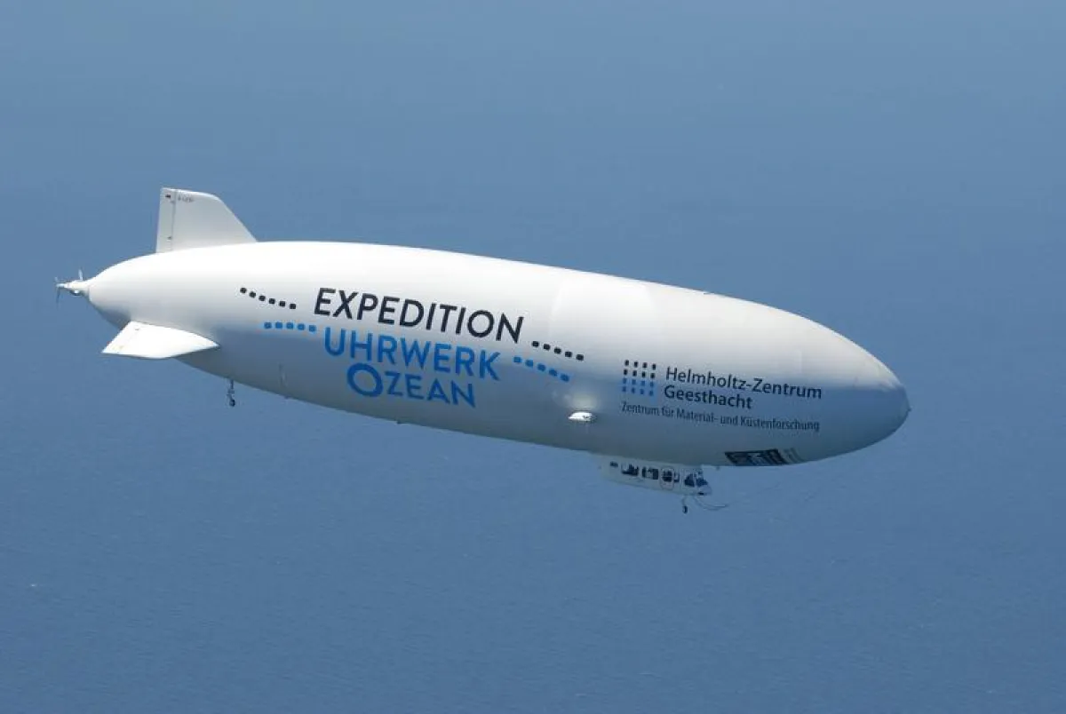
The zeppelin will fly from Cuxhaven over Hamburg Harbour on September 21st, 2017, arrive in Geesthacht around 11:30 AM, continue up-river along the Elbe, past Lauenburg to Cumlosen in Lower Saxony and finally back via Hamburg to Uetersen Airport.

Among other activities, the UFZ’s research ship Albis will concurrently take water samples in the river cross section for biogeochemical measurements between Wittenberge to the Geesthacht locks. Schnackenburg or Cumlosen are possible meeting places for the zeppelin and the research ship Albis between 1:00 PM and 2:00 PM.

Invitation for Media Representatives
On September 20st, 2017, at 4:30 PM, scientists are available for interviews, and photos can be taken with the zeppelin at Uetersen Airport. Please note: due to wind and weather conditions the zeppelin's arrival could be shifted. We will keep you informed of the current situation after you register.

Registration by email is required: E-Mail

We are happy to provide footage and image material on request.

Further Information
MOSES (Modular Observation Solutions for Earth Systems) is a Helmholtz Association project that studies processes that take place in complex event chains and that link the oceans, coasts, land surfaces and atmosphere. The HZG is involved in two event chains. On the one hand, the HZG oversees the “ocean eddies” event chain, in which researchers make use of a zeppelin, airplanes, speedboats and autonomous diving robots and develop numerous measurement methods.

Led by Prof Burkard Baschek, Institute Director at the Institute of Coastal Research, scientists at the HZG used a zeppelin for the first time to successfully measure ocean eddies in 2016. This time around, the special cameras will examine mudflats and the Elbe. Among other instruments, an infrared camera on board the zeppelin generates water surface temperature maps recording fifty images per second. The thermal imaging camera measures even the smallest temperature differences of 0.03 degrees Celsius.
The HZG also participates in the "Hydrological Extremes" event chain, which aims to monitor the effects of a severe rain event from the atmosphere to the land surface, into the Elbe and the North Sea.

For this purpose, the first measurements will be carried out jointly with AWI and UFZ in order to draw a comparison with normal conditions. The emphasis lies in the numerous biogeochemical processes, which are vitally important in the Elbe – the interaction of nutrients, oxygen and productivity are of particular interest.

A zeppelin, the three research ships Ludwig Prandtl (HZG), ALBIS (UFZ) and Uthörn (AWI) are used as instrument platforms. Furthermore, measurements are taken at the permanent stations operated by COSYNA (Coastal Observing System for Northern and Arctic Seas) in Cuxhaven and at the underwater node in Helgoland.

The underwater node provides a permanent power and data connection at a water depth of approximately eleven metres to connect scientific instruments and to operate them remotely. Thus, for example, current, salinity and oxygen as well as fish and soil-dwelling animals can be continuously recorded and studied over the course of the annual cycle. The data sets obtained in this way are an important basis for addressing questions on the change of environmental conditions in the North Sea. The underwater node was developed by AWI and the HZG and began operation in 2012.

The UFZ research ship ALBIS studies the spatial and temporal variability of material input from the Middle Elbe into the tidal area during low water conditions. The scientists take water samples in the river cross section between Magdeburg and the Geesthacht locks, process them directly in the ship’s laboratory and examine them, for example, for nutrients, organic cumulative parameters and trace elements.

Optical measurements of the water and the surface of the mud flats can meanwhile be recorded by satellite – and most importantly by a zeppelin in extremely high resolution. In order to ensure a correct interpretation of the data, comparative measurements on the ground and in the water are necessary. These measurements are carried out by the HZG in the Elbe estuary and at the mud flats off Otterndorf.

Measuring the Mud Flat Region: The position and condition of tidal channels, mussel and tempestite banks, sea grass inventories and beach areas as well as the morphological changes in the mud flats and the development of vegetation on the islands can be recorded from the zeppelin. The related data is analysed on Neuwerk, Scharhörn and Nigehörn by the Wadden Sea National Park in Hamburg.

Current Measurements. The latest developments in drone technology can be used in combination with radar measurement methods to carry out high-resolution current measurements from the air. These are undertaken by the HZG near Lauenburg by the zeppelin, drones and the small research vessel Zwergseeschwalbe (HZG).

The expedition has been made possible through the new initiative MOSES: A total of twenty-eight million Euros has been made available to the participating research centres for MOSES development and operation. Within the framework of MOSES, the first expedition involves more than twenty researchers. With the novel, mobile and modular MOSES concept, dynamic and long-term observation methods are to be directly linked with one another for the first time and to be used at short notice during flood events.

Weitere Informationen:
- https://www.hzg.de/public_relations_media/news/070094/index.php.en further information about the expedition on the HZG-Website

Quelle: idw

Diese Pressemeldung wurde auf openPR veröffentlicht.

Verantwortlich für diese Pressemeldung:

News-ID: 969349
 398

Kostenlose Online PR für alle

Jetzt Ihren Pressetext mit einem Klick auf openPR veröffentlichen

Jetzt gratis starten

Pressebericht „The Wadden Sea and the Elbe Studied with Zeppelin, Drones and Research Ships“ bearbeiten oder mit dem "Super-PR-Sparpaket" stark hervorheben, zielgerichtet an Journalisten & Top50 Online-Portale verbreiten:

PM löschen PM ändern
Disclaimer: Für den obigen Pressetext inkl. etwaiger Bilder/ Videos ist ausschließlich der im Text angegebene Kontakt verantwortlich. Der Webseitenanbieter distanziert sich ausdrücklich von den Inhalten Dritter und macht sich diese nicht zu eigen. Wenn Sie die obigen Informationen redaktionell nutzen möchten, so wenden Sie sich bitte an den obigen Pressekontakt. Bei einer Veröffentlichung bitten wir um ein Belegexemplar oder Quellenennung der URL.

Pressemitteilungen KOSTENLOS veröffentlichen und verbreiten mit openPR

Stellen Sie Ihre Medienmitteilung jetzt hier ein!

Jetzt gratis starten

Weitere Mitteilungen von Helmholtz-Zentrum Geesthacht - Zentrum für Material- und Küstenforschung

Bild: Realer Versuch statt virtuellem Experiment: Erfolgreiche Prüfung von NanodrähtenBild: Realer Versuch statt virtuellem Experiment: Erfolgreiche Prüfung von Nanodrähten
Realer Versuch statt virtuellem Experiment: Erfolgreiche Prüfung von Nanodrähten
Mit neuartigen Experimenten enträtseln Forscher des Helmholtz-Zentrums Geesthacht und der Technischen Universität Hamburg, warum winzige Metallstrukturen extrem fest sind --- Ultraleichte und zugleich extrem feste Werkstoffe – poröse Nanomaterialien aus Metall versprechen hochinteressante Anwendungen unter anderem für künftige Flugzeuge, energieeffiziente Autos und sicherere Industrieanlagen. Wie die bemerkenswerten Eigenschaften der Nanoteilchen im Detail zustande kommen, war bislang noch nicht genügend verstanden. Forscher des Helmholtz-Ze…
GERICS: Zwei neue Reports zur Anpassung an die Folgen des Klimawandels erschienen
Innovativ, individuell und regional – GERICS berät Städte bei der Anpassung an die Folgen des Klimawandels. Um Entscheidungsträger von Städten und Gemeinden individuell bei der Auswahl von lokalen und regionalen Anpassungsmaßnahmen zu unterstützen, wurde am Climate Service Center Germany (GERICS) des HZG der sogenannte GERICS-Stadtbaukasten entwickelt. --- Der Klimawandel und die fortschreitende Urbanisierung sind eng miteinander verknüpft. Bereits heute sind Städte für den Großteil des weltweiten Energieverbrauchs und der damit verbundenen …

Das könnte Sie auch interessieren:

Bild: Giant boulders on the coast of the Bahamas are evidence of ancient stormsBild: Giant boulders on the coast of the Bahamas are evidence of ancient storms
Giant boulders on the coast of the Bahamas are evidence of ancient storms
… Alessio Rovere, along with scientific colleagues from MARUM – Center for Marine Environmental Sciences of the University of Bremen and from the Leibniz Centre for Tropical Marine Research (ZMT), have now discovered that storms with intensities that are not uncommon today combined with a few meters increase in sea level would be sufficient to achieve …
Bild: Drones can almost see in the darkBild: Drones can almost see in the dark
Drones can almost see in the dark
UZH researchers have taught drones how to fly using an eye-inspired camera, opening the door to them performing fast, agile maneuvers and flying in low-light environments. Possible applications could include supporting rescue teams with search missions at dusk or dawn. --- To fly safely, drones need to know their precise position and orientation in space …
Bild: Species Richness – a false friend? Scientists want to improve biodiversity assessmentsBild: Species Richness – a false friend? Scientists want to improve biodiversity assessments
Species Richness – a false friend? Scientists want to improve biodiversity assessments
… short-term changes in the number of different species it contains can lead to false conclusions. This is according to a new analysis by an international team including researchers of the Helmholtz Institute for Functional Marine Biodiversity (HIFMB) at the University of Oldenburg and the German Centre for Integrative Biodiversity Research (iDiv). In order to …
Bild: Lessons for the future from past storm wavesBild: Lessons for the future from past storm waves
Lessons for the future from past storm waves
… Alessio Rovere, along with scientific colleagues from MARUM – Center for Marine Environmental Sciences of the University of Bremen and from the Leibniz Centre for Tropical Marine Research (ZMT), have now discovered that storms with intensities that are not uncommon today combined with a few meters increase in sea level would be sufficient to achieve …
Bild: Online Watt erfahren: Neue Infoplattform für Klassenfahrten ans WattenmeerBild: Online Watt erfahren: Neue Infoplattform für Klassenfahrten ans Wattenmeer
Online Watt erfahren: Neue Infoplattform für Klassenfahrten ans Wattenmeer
Die neue Website der International Wadden Sea School iwss.org bietet ein umfassendes Info- und Service-Angebot zur Planung und Durchführung von Klassenfahrten ins internationale Wattenmeer. Die Nordseeküste und das Wattenmeer zählen zu den beliebtesten Reisezielen für Klassenfahrten. Wo und wie Schülerinnen und Schüler dieses einzigartige Naturgebiet …
Bild: Expedition to study air quality and climate change around the Arabian Peninsula completedBild: Expedition to study air quality and climate change around the Arabian Peninsula completed
Expedition to study air quality and climate change around the Arabian Peninsula completed
… atmosphere --- After a good two months and nearly 20,000 kilometers at sea, an adventurous expedition to study air quality and climate change was completed. On September 3rd, the research vessel Kommandor Iona docked in the port of Seyne-sur-Mer in the South of France and discharged the members of the AQABA scientific expedition. (The acronym is short …
Bild: Klimawandel zum Anfassen für die Gewinner des Wettbewerbs „Berliner Klimaschulen“Bild: Klimawandel zum Anfassen für die Gewinner des Wettbewerbs „Berliner Klimaschulen“
Klimawandel zum Anfassen für die Gewinner des Wettbewerbs „Berliner Klimaschulen“
… ihrem Projekt „Energiesparen – Energieformen – Energiegewinnung“. Als ersten Preis gab es für die Grundschüler eine viertägige Klassenfahrt ins Wattenmeer mit der International Wadden Sea School (IWSS) und dem Hamburger Reiseveranstalter explore&help. Die Schüler/-innen aus Berlin verbrachten vier spannende und auch lehrreiche Tage im Wattenmeer in …
World’s first LNG-fuelled coaster to be classed to DNV
… organisation promoting emissions reductions. The designer of the vessel, Nordnorsk Skipskonsult worked closely with DNV on design specifications. Roald Vårheim, DNV’s head of ships and offshore structures, says that DNV’s early involvement in the project allowed Nordnorsk Skipskonsult to manage the project efficiently. “DNV moved quickly to provide …
Bild: Versatile marine bacteria could be an influence on global warming, scientists discoverBild: Versatile marine bacteria could be an influence on global warming, scientists discover
Versatile marine bacteria could be an influence on global warming, scientists discover
… Planck Gesellschaft, the Deutsche Forschungsgemeinschaft, BMBF, the Vienna Science and Technology Fund, the Austrian Science Fund, the Netherlands Organisation for Scientific Research, and the UK Natural Environmental Research Council. Original publication: Adaptability as the key to success for the ubiquitous marine nitrite-oxidizer Nitrococcus Jessika …
Bild: Arctic sea ice once again shows considerable meltingBild: Arctic sea ice once again shows considerable melting
Arctic sea ice once again shows considerable melting
Joint Press Release from the Alfred Wegener Institute Helmholtz Centre for Polar and Marine Research (AWI), the University of Bremen, and the University of Hamburg’s Centre for Earth System Research and Sustainability (CEN) --- With a minimum extent of ca. 4.7 million square kilometres, Arctic sea ice continues to retreat This September, the extent of …
Sie lesen gerade: The Wadden Sea and the Elbe Studied with Zeppelin, Drones and Research Ships